
The streets of Southern Manhattan, including areas like the Financial District and the Village, are seen as disorganized or chaotic compared to the rest of Manhattan due to the way the city was developed historically.
Most of Manhattan is in a grid that easily understandable once you learn the secrets (covered elsewhere in New York City Little Black Book). However, the southern tip is a confusing maze of streets. Why?
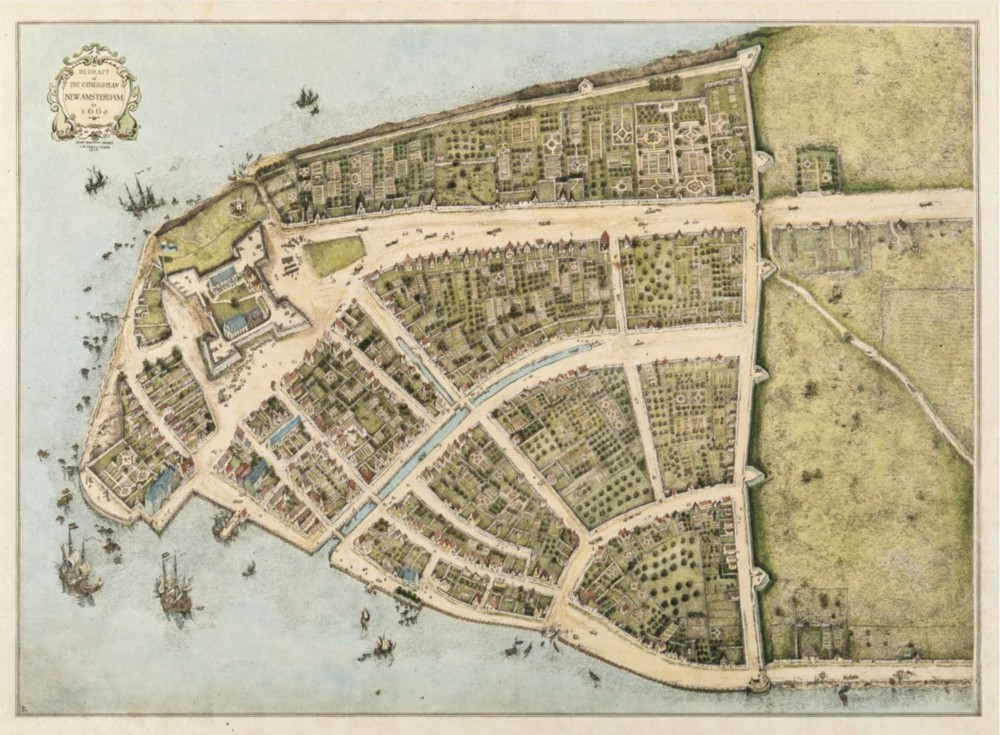
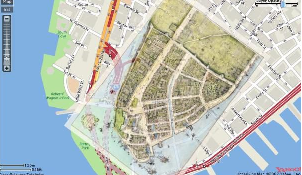
New Amsterdam’s population was around 2,000. There was no centralized plan and the city grew organically. On the southern end of the island, many of the original Dutch streets remain and the ones that came after tended to be short and narrow, other than Broadway which had been a main Native American thoroughfare. The rest of the island of Manhattan was mostly meadows, farms, ponds and marshes. Early roads tended to follow the easiest terrain.
Here are a few more reasons:
- Historical Development: New York City started as a Dutch colony named New Amsterdam in the early 17th century. It was originally confined to the southern tip of Manhattan. The early streets were designed and grew organically according to the topography and the needs of the time. There was no formal city planning, so the roads took on a winding, irregular pattern.
- Topography: The landscape also influenced the city design. Streets were constructed to accommodate hills, valleys, and natural features like streams and ponds. This created a lack of grid-like organization.
- The 1811 Commissioners’ Plan: The plan that organized most of Manhattan into a grid system (this grid starts at Houston Street and continues north up to the top of the island) did not include much of southern Manhattan. This was because by the time this plan was implemented, lower Manhattan was already densely populated and developed, making it difficult to impose a grid system.
- Land Ownership: When the city was initially developing, properties were often defined by physical features such as streams or hills. Individual landowners would then build paths or roads that best suited their own properties, resulting in irregular patterns.
- Historic Preservation: Many of these older streets have been preserved for their historic value, even as the rest of the city around them has modernized and become more uniform. This adds to the charm and uniqueness of southern Manhattan, but also contributes to the perceived disorganization of its streets.
While the streets in lower Manhattan may seem disorganized, they reflect the city’s rich history and evolution over hundreds of years. In fact, many New Yorkers and visitors alike find charm in this part of the city for its departure from the regimented grid system.
Another thing as the city great was the shoreline of Manhattan expanded with landfill. The World Trade Center area was originally part of the Hudson River. A number of bays, especially along the East River, were filled in. Look at how the original New Amsterdam would look if overlaid on the current tip of Manhattan.
Of course, that doesn’t help you if you get lost.
I always enjoyed walking around that part of the city which has a rich history. Early in the morning, the night after my prom (held out in Flushing) we ended up in a small diner just before dawn for breakfast. A waitress who looked like Morticia from the Addams Family served us. She made her way, many years later, into New York Minute, my series set in the city in 1977. Indeed, that whole area and the old High Line and the disintegrating West Side Highway make an appearance.
Recent Comments